Difference between revisions of "Star map"
m |
|||
| Line 4: | Line 4: | ||
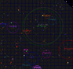
[[Image:Starmap 2158.png|right|300px|thumb|Image 2: Starmap in 2158 showing Spheres of Influence.]] | [[Image:Starmap 2158.png|right|300px|thumb|Image 2: Starmap in 2158 showing Spheres of Influence.]] | ||
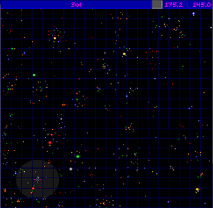
| − | The '''Starmap''', or star chart, is the map of our corner of the galaxy. It is divided into a grid of 20x20 squares, with each square consisting of | + | The '''Starmap''', or star chart, is the map of our corner of the galaxy. It is divided into a grid of 20x20 squares, with each square consisting of fifty degrees space-latitude by fifty degrees space-longitude. The canonical term used to describe latitude and longitude is ''[[Standard HyperSpace distance unit]]'', or HSDU. The Starmap shows a 1000x1000 HSDU section of space. |
While viewing the map, the lowest X-Y co-ordinate is (002.1 : 002.1) and the highest is (999.9 : 997.7). The imaginary line connecting the two points is the [[Coreward]] direction and travel between the two points requires 141.3 units of fuel for the Flagship. Oddly, the Flagship can travel to the co-ordinates (000.0 : 000.0) and (999.9 : 999.9) which will be shown in the Navigation screen, but the ship's location on the map will be (002.1 : 002.1) and (999.9 : 997.7) respectively. | While viewing the map, the lowest X-Y co-ordinate is (002.1 : 002.1) and the highest is (999.9 : 997.7). The imaginary line connecting the two points is the [[Coreward]] direction and travel between the two points requires 141.3 units of fuel for the Flagship. Oddly, the Flagship can travel to the co-ordinates (000.0 : 000.0) and (999.9 : 999.9) which will be shown in the Navigation screen, but the ship's location on the map will be (002.1 : 002.1) and (999.9 : 997.7) respectively. | ||
Revision as of 21:28, 18 July 2015
The Starmap, or star chart, is the map of our corner of the galaxy. It is divided into a grid of 20x20 squares, with each square consisting of fifty degrees space-latitude by fifty degrees space-longitude. The canonical term used to describe latitude and longitude is Standard HyperSpace distance unit, or HSDU. The Starmap shows a 1000x1000 HSDU section of space.
While viewing the map, the lowest X-Y co-ordinate is (002.1 : 002.1) and the highest is (999.9 : 997.7). The imaginary line connecting the two points is the Coreward direction and travel between the two points requires 141.3 units of fuel for the Flagship. Oddly, the Flagship can travel to the co-ordinates (000.0 : 000.0) and (999.9 : 999.9) which will be shown in the Navigation screen, but the ship's location on the map will be (002.1 : 002.1) and (999.9 : 997.7) respectively.
The location of The Flagship is designated by a grey circle and its possible destination by a pink compass star; the trajectory between the two points is represented as a dotted blue line and the projected fuel consumption is shown. When the Flagship makes contact with a race, their Sphere of Influence is added to the Starmap in the form of a coloured circle, with their name, that corresponds to the location of their fleet.
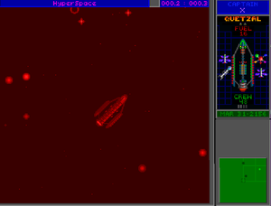
In Navigation mode (Image 3), the main screen shows the Flagship's location, and to the right is a smaller, green mini starmap that shows the Flagship's immediate position with nearby stars and any approaching vessels.


